![]()
Founded 1906
Field Unit Archive 2002 Page 1
|
|
|
|
|
|
|
|
|
|
|
|
|
|
|
|
|
|
|
|
|
|
|
|
|
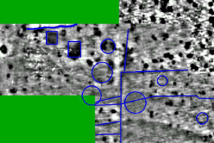
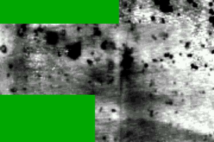
* Original Information April 2002 * New late April 2002 (as featured in the Evening Aurgus) * July 2002 * 7th Sept 2002 * 28th Sept 2002 Rocky Clump Geophysics * 25th November 2002 Brighton Roman Villa (Next Page) * 15th January 2003 Final Thoughts at Rocky Clump Geophysics at Ovingdean The geophysical information has been passed to the County Archaeologist. A study was made of the information using the County's sophisticated technology, but anomalies are very ephemeral. There were a number of interesting areas, but the survey failed to produce well defined features. It may prove to be that the site has been ploughed away. A small excavation may provide further information. The Brighton and Hove Archaeological Society Field Unit began working in the field north of Ovingdean church on Saturday 30th March. The field has been the subject of a geophysical survey on a number of occasions producing areas of extremely high resistance with clearly defined linear arrangements (see pictures and addtional info). The nature of the readings form some type of enclosure, with lines running away from, and parallel to the north wall of the church. The excavation has been organised to investigate the anomalies found on the resistivity survey. A total of 5 trenches have been cut to answer a number of questions. Are the anomalies walls and floors, and if so what period do they date from. The excavations have produced very interesting results. The trenches have uncovered a number of well constructed flint walls, probably footings for buildings, with smaller flint walls for ancillary buildings. One trench has a substantial flint constructed feature, with a curved outer wall. A large cobbled area within the compound may be the location of a courtyard. A possible well may also have been found, but excavations continue and further evidence may confirm this. The small excavation suggests that a substantial building may have stood in the field during the medieval period. Finds from the various pits have included medieval pottery, including 13th century green glazed wares, bone, oyster shells and some metal work. A few pieces of dressed stone and a piece or medieval ribbed roofing tile, hint that the building had some status. Local historian John Davies has suggested that the field, close to the church, could be the location of a 'thegnly' manor. An examination of the walls by archaeologist Chris Butler has placed the building of the walls at not later than the 13th century and probably earlier. It was during the 14th to 15th century that the medieval presence moved down the slope of the hill to Ovingdean Grange, and it is very possible that the original building was robbed of building materials for the creation of the new house. The results of the excavation will be published at a later date and the finds deposited with Brighton Museum. The residents of Ovingdean have been regular visitors to the site. An added bonus to the excavation is that the tenant farmer, Mr David Baker, who also gave permission for the excavation, regularly trains his group of cart horses adorned in all their refinery in the same field.(see pictures) The Field Unit conducted an excavation of 7 trial trenches in the field known as Hogs Croft Ovingdean. The object of the investigation was to determine the nature of the high resistance readings found during the geophysical surveys conducted in 1986, 1991 and 1999. Every trench produced archaeological features and artefacts. The investigation revealed floors, walls and large areas of tumbled flint; a chalk platform was recorded on the east side of the site. Finds included pottery, bone, molluscs, a spindle whorl, metal work of various descriptions (including an axe), and jewellery of 19th century date. A significant site dated to the l2th/l3th century lies beneath this field at Ovingdean. The artefacts are being processed and an interim report will be drafted within the next eight weeks. Geophysics at Duddleswell The Field Unit assisted Chris Greatorex with his study of a garden behind the tea rooms at Duddleswood, in Ashdown Forest. The garden was examined in two areas together with part of a neighbour's garden; the gardens are crossed by a known Roman road. The results from the survey produced a significant number of high readings, enough to confirm that the road is located where anticipated. A group of the Unit walked through scrub to Duddleswell church and found that the Roman road continues as an agger and flanking ditches for some distance. Geophysics at West Burton, West Sussex. In February the Field Unit carried out a large geophysical survey at West Burton, West Sussex. The project was at the request of Mr David Shears a local historian from that area. The area investigated is thought to be the site of a deserted Medieval village (DMV), and lies close to the church. The examination of the area over the Christmas period showed a number of earthworks and mole hills produced significant quantities of pottery and tile. The survey produced a series of really interesting readings, and Andrew Woodcock has suggested that some of these could show building configurations. An extension to the survey is planned for the coming season. The Field Unit have been contacted regarding an extension to the survey already conducted. A new survey is planned for late July or early August. Several members of the team have been conducting a geophysical survey of lands around the church at West Burton, West Sussex. The site is the possible location of a deserted medieval village (DMV). The day was also used as a training exercise for new members of the team and those wishing to enhance their existing experience. The results were downloaded using our new soft ware from Geoscan and a new software developed by a member of the geophysical team, David Staveley. The results have produced a number of linear anomalies (see pictures in gallery). Dr Andrew Woodcock has suggested that the survey conducted by the unit during the earlier part of the year had platforms that may be associated with medieval buildings. The figures have been passed to David Shears of the West Burton group, whether further archaeological investigation is undertaken will be determined by the West Burton team. Details of the project will be passed to West Sussex Sites and Monuments Records (SMR). Excavations at Rocky Clump The Field Unit have taken advantage of some good weather to begin removing a new section of top soil, north of the existing excavations. The existing open area has been subjected to some frost damage and this has restricted access, until the warmer weather dries out the ground. A flint concentration is already being observed on the east side of the new area suggesting yet another floor layer. The area between this cobbling and the chalk bedrock on the west side is a soft fill of chalky loam. The 2001 geophysical survey suggested that this is a very disturbed area and the archaeology tends to confirm this. Excavations at Rocky Clump continue with priority given to the planning of a section drawing of the deep trenches. The drawing activities are being used for the training of BHAS personnel. New post holes have been revealed in the new section north of the existing site. The excavations will continue throughout the summer despite a number of the Unit being asked to assist the MSFAT team with their excavations at Barcombe. The flint floor' on the baulk is now fairly well established, as in context 525 it appears to have sunk sunk into the centre section, which is the soft fill of the large ditch. Going north, the ditch and terrace west boundary were found, the east side is still being sought, this should prove easier now that the south facing section drawing has now been completed and the remaining baulk on the north side can be removed. The centre baulk is producing finds of pottery and bone, and can be removed with a clearly defined stratigraphy. The deep planning of the south section is now complete leaving only the remaining planning on the north deep section. Excavations at Rocky Clump have concentrated on the large remaining baulk section. The well stratified layers are being removed in chronological sequence. The first feature to be removed was the large north/south ditch fill. This fill is a soft black silty layer and has produced pottery, including part of a butt beaker, animal bone, consisting of both cattle skull and pelvic sections and a number of oyster shells. The ditch fill has produced a beautiful brooch dated to the 1st century A.D. Parts of this ditch fill are still being removed. The layers below consist of chalky loam comprising a mixture of medium chalk nodules and small flint pieces. Large pottery pieces have been found in this lower strata, but are as yet undated. A news section of trench has been uncovered, 4 metres north of the existing excavation and it appears that the very large pit presently being excavated has grown even wider as it progresses north. The new pit is now almost 8 metres in width. A number of features on the east side of the pit may prove to be post holes, and are awaiting sectioning. The excavation will continue throughout the autumn until the weather deteriorates. Finds processing is being organised for the autumn and winter months. Finds from both Ovingdean and Rocky Clump will be processed, and volunteers are encouraged to come along for hands on marking and cataloguing of artefacts from both excavations. As a result of the geophysics from September 23rd there are three pictures, one is the non-flattened results, the second is a flattened version which shows up the ditches better and the third is an interpretation (provisional only).
All the features marked are low resistance as nothing of high resistance shouts wall! There are a couple of rectangular features near the clump, several boundary ditches and a few possible round houses around the ditched area. Geologically, there is an interesting change near the bottom of the survey, and also there are a whole heap of black blobs, which are probably something like solution or clay with flints. Much Samian was found around the middle of the survey, roughly between the rectangular and round features, along with a small pile of the usual sort of pot we would find at the clump. There was even a piece of tile with plaster on it! The season at Rocky Clump closed on 31st December with a magnetometer survey of the field to the east of the copse at Rocky Clump. The survey found a new ditch moving in a circular direction, parallel to the inner ditch surrounding the trees. The survey failed to find a distinct pattern of post-holes for a rectangular building indicating a settlement site. During this season a major resistivity survey was carried out in the south field and a smaller area in the north field totalling 18.800 square metres. Using both the recently purchased Geoscan software, and the software developed by David Staveley, has resulted in an enhanced and detailed survey of this large area (see picture). The geophysics has revealed a vast number of low readings, indicating either post- holes pits or geological solution hollows. There is no clear definition of any rectangular building as excavated in the past 5 seasons, but enough features to produce any number of circular configurations suggestive of Iron Age round houses. One particular area has a hint of a possible ring gully? It would appear that only assessment excavation can actually determine whether the low readings are post holes or solution.
The main excavation has revealed a very complex area of large pits, sealed by flint floors, a rich silty north/south ditch contained a large selection of butchered animal bone. Among the pottery were a number of pieces of indented beaker and the metal finds included a bronze depressing tool, a brooch and a number of hob nails. The chronology or sequence of creation of the various pits is being analysed, but it is clear that the main north/south ditch had a number of phases. This large feature is joined by another ditch running east/west, this ditch widens dramatically as it joins the other. At the junction of the two ditches is a large pit and into this pit runs a small gully. The pits were back filled over a period of time with each successive layer being systematically sealed with a flint layer. It is not possible to determine whether this sealing had a ritual or purely functional purpose. The reason for the pits is difficult to understand, they may be part of complex of marling pits, for removing the acidity of the upper layers of clay soil, they may be rubbish pits, or marl pits later used as such. The pits do not cut the large north/south ditch on its west side but open up onto it. They are all at the same depth level which may hint at some unknown agricultural purpose. The finds from this small area have included a number of peculiar burials and other sequences that do hint at ritualistic rather than common waste usage. The cow burial, the dog burial, now according to Jeremy Adams at the Booth Museum an almost certain pet burial, lie very close to the other burials of a cow skull over winkle shells, and a sheep skull over oyster shell deposits. These earlier finds certainly hint at some form of ritual activity. (see pictures). Rocky Clump is proving to be a very interesting excavation and the large ditch and new areas of pit features will provide new areas of interest for next season. |
||||||||||||
|
|