![]()

Founded 1906
|
|
|
|
|
|
|
|
|
|
|
|
|
|
|
|
|
|
|
|
|
|
|
|
|
Original Information 2001 * Update 13th June 2001 * Update 18th July 2001 *Update 28th Sept 2001 *Update 8th Oct 2001 * Update 5th Jan 2002
|
||||||||||||
|
During the latter part of October and November members of the BHAS Field Unit conducted a geophysical survey at fields near the village of Ovingdean. A field walking exercise in 1999 located significant concentrations of pottery dated to the Iron Age and Roman periods. A note on the sites and Monuments Records (SMR) notes Roman pottery found on a previous occasion. The survey was conducted over 7200 square metres and during the survey quantities of pottery, including Samian ware were recovered. The results from the survey are very ephemeral and do not produce evidence for villa remains in the area surveyed, however a number of circular features may prove to be evidence of Iron Age round houses. The survey will continue in the spring and a small excavation may be planned for the future to examine the circular anomalies. (see pictures) Geophysics at Chichester The BHAS Field Unit joined with the Chichester and District Archaeological Society on Saturday 7th July, to conduct a geophysical survey north of Chichester. A Roman road is known to run northwards from the ancient Roman town of Noviamagus, but little trace has been found of it. Houses along Lavant Road have gardens that may be cut by the road, after kind permission was granted from the house owners, a resisitivity survey was conducted over an area of 350 square metres. The readings tend to show that an area of high intensity is located in these gardens which may indeed show the main feature itself, the data processing is being undertaken to determine whether the side drainage ditches can also be located. The survey produced a considerable amount of high readings in both gardens. An area of particularly high readings was found in the west square at number 11 Lavant Road and high readings continued eastwards, although these were less intense. However, the readings were of a dispersed configuration and did not conform to a linear pattern which would have suggested a road type feature running from north to south. Similarly the garden at No 51 produced significantly high readings, but again in a very dispersed arrangement . Perhaps the most interesting aspect of the results from No 11 Lavant Road is that they may suggest a linear arrangement proceeding in an east/west alignment. No traces of flanking ditches were found in either survey. The results from the survey tend to suggest geological anomalies rather than archaeological, but one other consideration could be that the building materials from the road have been removed and used elsewhere. BHAS Field Unit at Barcombe Roman Villa All members of the unit are requested to join the Mid-Sussex Field Team at Barcombe until further notice, as the excavation is proving to be far more extensive than previously anticipated. Excavations at Rocky Clump should begin again in late August when Barcombe concludes. (see photo). Update on Geophysics at New Place, Pulborough The graphical output from the resistivity survey at Old Place suggests that the extensive wall features were indeed linked to the main house at one time. A further set of high readings may provide evidence for another building or features under the west lawn. Update on Geophysics at Beedings, Pulborough The geophysical survey at Beedings, near Pulborough, failed to find the anticipated ditch running close to the house. The nature of the readings suggest that there is very little archaeology in the way of features in that area. However, a watching brief is being planned for the area of land where an extension is being added to the house (see photo and geophysics). Geophysics at New Place, Pulborough The BHAS Field Unit conducted a geophysical survey in the gardens of New Place Pulborough during early June of this year. The house probably dates to the Tudor period or earlier and is constructed of stone. The garden wall contains a number of areas of significant stonework and it suggests that a hall or additional building may have originally been attached to the existing building. The geophysical survey was to examine the area adjacent to the house to search for high resistance indicating the location of possible walls. The information is currently being processed and should the results prove positive then a small excavation is being planned to determine the nature and age of features revealed. Excavations at Stanford Avenue Brighton During April 2001 the Brighton and Hove Archaeological Society Field Unit conducted a small excavation in the garden of a house at the lower (west) end of Stanford Avenue, Brighton. The site lies close, within 200 metres, to the location of the known Roman villa. The assessment trench measured 5 metres by 2.5 metres. The area was excavated down to a level 1.1 metres deep where the natural chalk was encountered. A bed of flint nodules lay immediately above the chalk bedrock and was while excavating these nodules in the 19th century for building materials that the villa site was first found. The small area was very heavily disturbed with a distinct double layer of top soil added at some period in the past. The section cut through a childrens sand pit still with toys of the 1970's period in situ. A trench had been cut through the garden going north to south with a lower deposit of contemporary tiles. A hard slag floor was also encountered. The finds were mainly of 19th and 20th century items, but 5 sherds of Roman and 1 thumbed Medieval piece were recovered. No features other than natural depressions were recorded in the trench bottom. The sections are currently being drawn and the site will then be back filled.
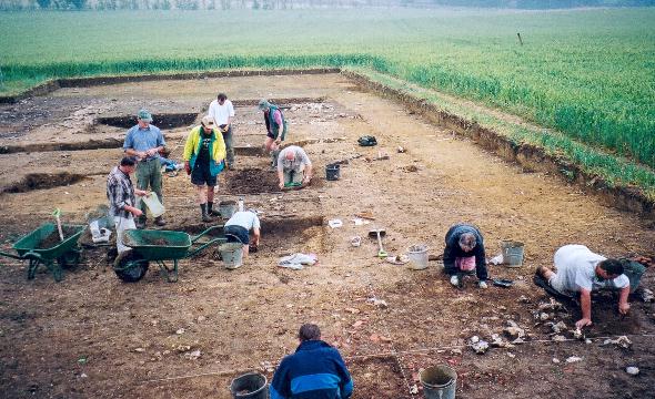
ROCKY CLUMP Excavations continues at Rocky Clump and will carry on until the end of the year. The sections removed so far have revealed a terrace on the east side of the trench, cut into the natural chalk. The terrace has a circular cut and may prove to be a possible round house. A pit/post hole has been cut into the lower fills producing significant quantities of bone, including a number of animal skulls. Samian ware has been found in a north/south ditch that cuts across the terrace on the west side of the trench. The 'wall' feature found in 2000 lies above this ditch and runs parallel to it . The section produced so fare clearly shows that the north south ditch cuts into the fill of the terraced area clearly making the terrace a much earlier feature. Examination of the finds during the winter months should produce accurate dating for the features. New volunteers have joined the group during the late summer and more can be accommodated. The large ditch running south to north produced a complete articulated burial of a Romano-British dog. A large pit on the north side of the excavation produced a complete cow burial. The animal had been bound at the feet when deposited in the large pit. The surrounding area has a number of pits and terraces cut into the natural chalk bedrock.(see photos) The new season at Rocky Clump has concentrated on the features already revealed. The large ditch running from west to east has been excavated and has found to contain a number of re-cuts. The ditch increases in depth and width as it joins the ditch running from south to north. The ditch running from south to north is also increasing in width as it moves north and down the hill, the ditch is cut by a number of pits that post date it and the ditch itself cuts an earlier very large pit running east to west. The new pit measures over 2.5 metres wide and is over a metre in depth. The upper section of this pit had been cut by a smaller pit containing quantities of samian pottery, this same pit, when excavated 'bottomed' down on to an articulated skeleton of a cow, see above. The site is providing important evidence into the agricultural activities of the Roman period in this part of the country. It would appear from what has been revealed so far, that cattle enclosures or buildings may have been cut into the chalk rather than have standing buildings above ground. The large north/south ditch has produced a significant collection of finds including disarticulated bone including considerable quantities of jaw bone, oyster shell, pottery and large iron nails. A number of small finds of bronze include a strap with a diamond shape perforation. The stratigraphy is proving quite complex. The large pit with the cow burial clearly continues towards the north, with the edge readily defined. A platform on the south section of the trench is still a peculiar feature and will not be explained until the central baulk is removed. The cuts into the chalk are quite significant and are obviously more than rough cut 'midden' sections. Hints of flint cobbled 'flooring' continue in several areas and the 'wall' feature, probably robbed in the past, appears to continue in the new section being opened. Geophysics at Rocky Clump A new survey around the excavated area was conducted in November of 2001. The survey produced the clearest images so far at Rocky Clump. The known ditches running from east to west were beautifully portrayed and it can be observed that they link with another large ditch running north to south on the west side of the field. The area of the cow burial is distinctly shown as a large area of low readings and this feature continues north, an extension to the existing site is indeed confirming further features, and a large pit is noted at the west junction of the ditches providing areas for further examination in the future.
GEOPHYSICS AT BINSTEAD, WEST SUSSEX During the past 2 years the Worthing Archaeological Society have been conducting excavations on a site close to the village of Binstead, West Sussex . This year the Worthing Society asked for the assistance of the Brighton and Hove Field Unit in conducting a geophysical survey prior to the commencement of excavations for the this years programme. The object of the exercise was to try and locate archaeological features prior to excavation. The excavations in 2000 had located a wall feature, probably associated with a known medieval tile kiln close by. A large ditch cuts across the west side of the field running north to south, a bank associated with the ditch is clearly defined. The ditch has been dated to the Iron Age. The opportunity was given for members of the Worthing Society to become proficient in the use of the RM15 resistivity equipment, and a training programme became part of the days activities. The results of the survey were very diverse. A concentration of high readings on the west side of the field produced no significant configuration, allowing no identification of archaeological features. An extremely set of high readings were found close to the field boundary among the hedgerow, however some form of hardened surface associated with the proximity of the road surface may have accounted for this difference. At Ovingdean the cattle ruts in a field produced significant areas of low readings close to the field boundary wall associate with water retention, the opposite effect may be happening at Binstead. A significant area of low readings were produced running close to the area of the Iron age ditch, and the Worthing Society considered that their previous excavations may also have contributed to the area of low readings.
UNDERGROUND CHAMBER FOUND AT ROEDEAN A watching brief being conducted at a house extension in Roedean, in February of this year, was organised to seek out evidence and record features and artefacts related to the Neolithic and Roman periods. After the topsoil had been stripped a large concrete slab was uncovered. A breach was made in the 12" thick concrete and an underground cavern revealed. The chamber, totally unknown before, measures 10 feet square (3.04M), it has a number of alcoves and a central sump going to a depth of 24". From the central chamber ran three narrow passages leading to sets of iron treads going up and out through trap doors. The trap doors had been sealed with concrete to prevent access. One of the passages led out and under the existing house ending at a series of steps leading upwards. The existing house was built in 1937. Inside the chamber were a number of contemporary items including recent electrical conduit, electrical fuse boxes and an 'air filtration unit'? (See photo). The discovery has left a number of unanswered questions, when was it constructed who built it and what purpose did it serve? The unit appears to be some form of air raid shelter or secret hideout. As the house standing was built in 1937 it would make the chamber a possible 1st World War item, unless it was abandoned after its construction during the early 1930's prior to the 2nd World War. The Royal Navy did have some association with nearby Roedean School during the 2nd World War when the school was used as a training establishment. Another possibility is that the underground hideout is part of the secret 'listening' posts created and hidden to allow subversive actions to take place in Brighton in the event of a successful Nazi invasion Mr Ron Martin of the Brighton and Hove Industrial Society is endeavouring to seek out further information, but if anyone has knowledge about this unusual feature or others that are similar, then the BHAS would dearly like to hear from them. |
||||||||||||
|
|